Moor, Please...

The Brontë walk from The Fleece Inn, Haworth | 7½ miles

Scanning the Ordnance Survey map of Haworth the footpaths to the west of the village appear to provide the best hiking opportunities. They do - but stand out not just because of the network they form but because of the fine landscape they pass through coupled with its literary associations. The Brontë Walk, as this route is known, is undoubtedly a Yorkshire classic.

The South Pennines have the beauty and emptiness of the Yorkshire Dales to the north but also some of the northern grit that emanates from Bradford to the south. This is uncompromising country of bare, brooding hills as perfect for contemplation and inspiration today as they were for those bookish sisters.

view interactive MAP

download leaflet

Directions

1

Turn left out of The Fleece Inn to the top of Main Street. Pass to the right of the church, parsonage and museum and along the public footpath signed to West Lane. Pass through a gap in the wall and, after some houses on your right, a metal gate.

Descend to the road and through a stone stile. Turn left then immediately left again still on road signed to Penistone Hill. As the road bears slightly left keep ahead and pass through a wooden barrier signed ‘Bridleway to Reservoir Road’.

Follow the track down to the reservoir and right along the top of its dam to Stanbury. At a T-junction turn left to pass through the village.

2

Where it ends fork left down Back Lane and keep left at the next fork signed to Top Withens and the Brontë Falls.

Pass through a metal gate beside a cattle grid then take the right fork along a gravel track signed to Top Withens.

Pass Upper Heights Farm to eventually ascend to Top Withens.

3

Retrace your steps briefly then turn right on the path signed to the Brontë Falls. Eventually descend via a kissing gate to cross the clapper bridge by the falls.

Maintain the same direction along what soon becomes a broad track towards the road.

4

After a cattle grid fork right signed to ‘Haworth via Penistone Hill’. Very soon cross the road and continue ahead signed ‘Public path. Urban common’. At the next fingerpost follow a gravel track signed to ‘Haworth 1 mile and Brontë Way’.

Keep ahead at a crossroads of paths then, after 20 yards bear left to descend to the road. Cross the road and continue steeply downhill on a walled lane signed ‘Public footpath to Haworth village’.

Turn left at T-junction of paths and pass a car park to return to the church in Haworth.

Why not pop back to The Fleece for a pint of Timothy Taylor’s finest ale and a bite to eat?

What's the walking like?

The route begins with two miles of minor roads.

Once on the moors it can get muddy but is always clear and well waymarked although not recommended in poor visibility.

After the Brontë Waterfall the surface improves again. Uniquely in Britain some of the signposts are in Japanese.

What are the best bits?

Top Withens. This former farmhouse is reputedly the setting for Emily Brontë’s Wuthering Heights although no-one is sure as explained by the comprehensive information boards.

The ruins have been substantially shored up and made safe in recent years. The resultant structure appears box-like in the landscape and reminiscent of some sort of Second World War military installation.

Another old farmhouse to the east of the Brontë waterfall remains in a more rickety and evocative state.

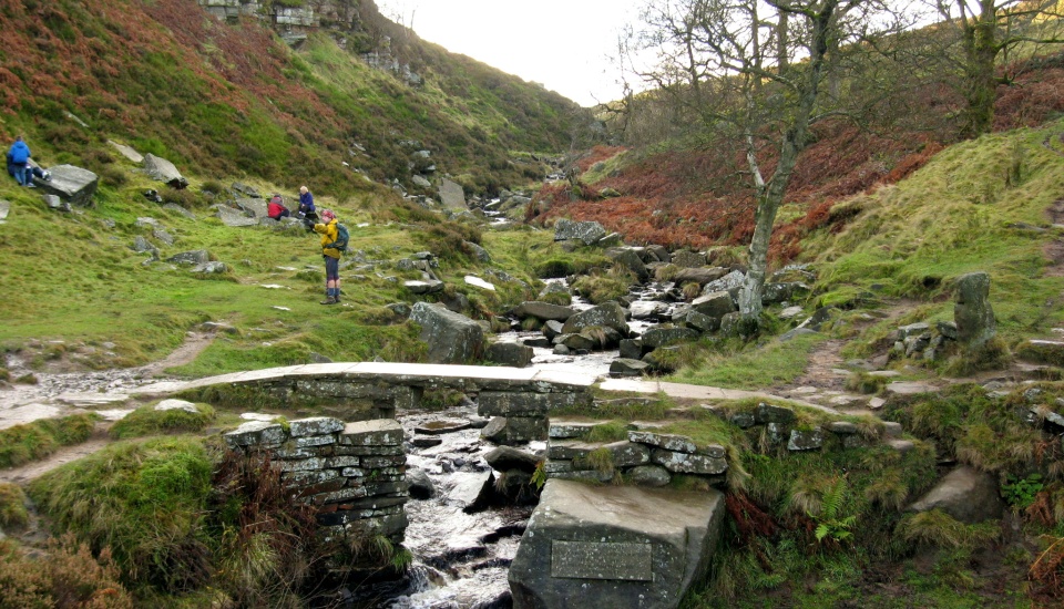
Brontë waterfall and bridge. The Brontë sisters visited this scenic spot on their regular walks from the parsonage. The old bridge was washed away by a flash flood in 1989 and rebuilt in 1990.

Look out for the Brontë chair, a seat shaped rock in which it is said the sisters used to sit and tell stories.

And what about lunch?

You will need to take a packed lunch since the route includes no cafés.

There are plenty of benches at Top Withens and stones to sit on at the Brontë bridge. You are unlikely to dine alone!

Discover more of our bespoke walking routes and bike rides

timothy taylor's pub walks & bike rides

Timed popup